
Sensor Geometry
We accurately model the acquisition geometry of imaging systems in order to optimise data georeferencing and ensure the reliability of all post-processing.
We develop hybrid solutions combining physical modelling and intelligible deep learning, enabling us to extract reliable and directly usable information from satellite data.
Sensor geometry: Magellium Artal Group’s historical expertise
The geometric modelling of an Earth observation sensor involves accurate description of the image sensing processus by incorporating all the instrumental, orbital and geophysical parameters that influence the path of light between the Earth’s surface and the sensor.
This step is essential for producing reliable data. In particular, it enables the correction of distortions and ensures the spatial consistency of images for use in applications such as mapping, geographic information systems (GIS) or multi-source fusion.
Beyond the absolute geolocation modelling, we develop estimation and calibration algorithms to refine acquisition parameters when these are uncertain or degraded.
These approaches are implemented in numerous use cases, such as:
- accurate orthorectification,
- multi-sensor and multi-date co-registration,
- 3D reconstruction (stereoscopy, photogrammetry),
- and the improvement of the geometric quality of products.
This expertise applies to various types of platforms: satellites, airborne sensors and UAVs.
The impact of deep learning on sensor geometry
We integrate deep learning methods to enhance traditional physical approaches, particularly to automate and improve complex tasks such as image registration, detection of homologous points, and parameter estimation.
These hybrid methods make it possible to:
- improve robustness in the face of noisy or heterogeneous data,
- reduce the need for manual parameterisation,
- speed up processing whilst maintaining a high level of interpretability.
Deep learning thus moves beyond the R&D framework to be put to operational use, with a focus on reliability and model control.

We design and implement geometric models and processing chains that enable high-precision geolocation and ensure data reliability for all further processing stages.
Contact us
Our Expertise
Geometric modelling
Bundle adjustment
3D reconstruction
Deep learning
Key projects
FLEX DISC
Since 2017, Magellium Artal Group has been actively contributing to the FLEX L2 projects for ESA’s FLEX mission through prototyping, the development of data processing chains, and the monitoring of mission operations and performance. As consortium leader since 2024, the EO unit will coordinate the entire project aimed at establishing the operational data processing chains and the performance centre for the FLEX space mission, with the aim of ensuring the performance of the data to be collected.
To find out more about the FLEX mission, click here.

Illustration of FLEX L2 satellite
3D reconstruction of urban areas
Through CNES contracts and our own investments, we are conducting a series of studies to build a 3D representation of urban areas using multi-stereo imagery such as Pléiades (50 cm spatial resolution). The work involves several phases: 3D reconstruction of the MNS from multi-stereo images (via stereo correlation), enhancement of the MNS (via deep learning), detection of building footprints (via deep learning), segmentation of roof slopes (via deep learning) and construction of LOD2 building models.
LibGeo
LibGEO is the CNES’s generic geometric library. Originally developed for the CO3D mission (CNES’s 3D optical satellites designed to map the planet in 3D), its scope has gradually been extended to all future CNES space imaging and surveying missions (IASI-NG, Microcarb, 3MI, TRISHNA, etc.). LibGEO aims to model satellite sensors and optimize these models to achieve precise geolocation of images. This project is carried out in partnership with the DGA (French government’s defense procurement and technology agency) and the IGN (French National Institute of Geographic and Forest Information (France’s national mapping agency) and benefits other institutions/companies like CEA, TAS, etc.

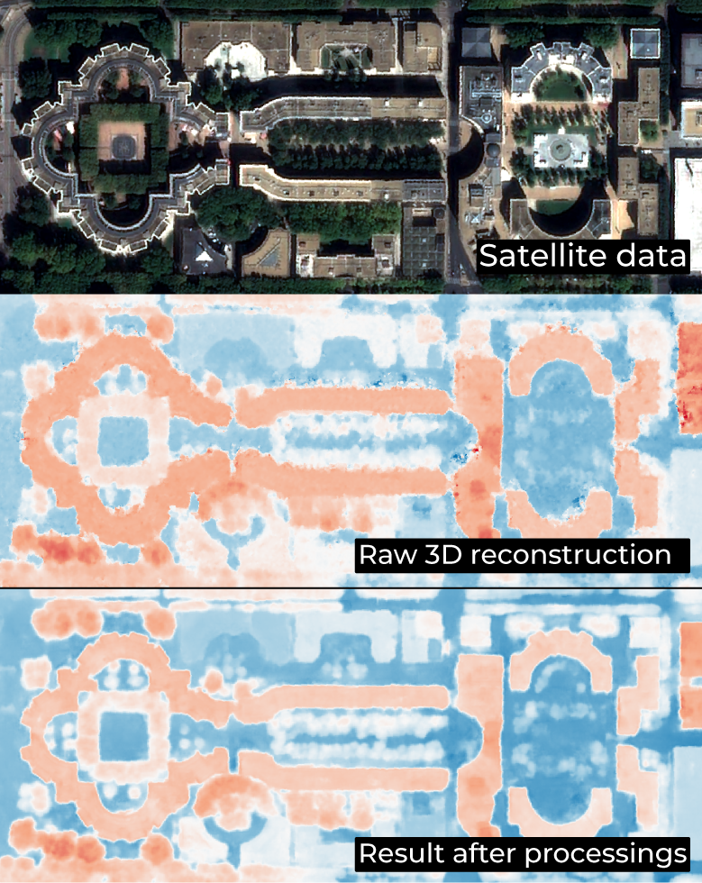
3D reconstruction, processed by Earth Observation unit
Our other expertises
Sensor geometry
We work with images acquired by Earth observation satellites. We build, optimise and use a geometric model of Earth Observation sensors.

Measurement Physics and Radiometry
Our expertise covers image quality, measurement physics and radiometry in the optical domain. This includes equalisation, stray light correction, absolute calibration, etc.

Ground segment
We provide Image Ground Segments for Earth Observation satellites, developing the processing chains, the orchestration, the cataloguing and archiving of the image products, including instrument simulation and ground-based processing prototypes.

Thematic Applications
We carry out scientific studies, manage projects on value-added products (L3/L4) and provide services in various thematic fields.

Space Surveillance
We have developed expertise and solutions for the detection and tracking of space objects (satellites and debris), from the ground or on board satellites.

SCIENCE FOR EARTH CARE
Magellium Artal Group’s Earth Observation unit provides expertise in optical space missions and geophysical and biophysical applications. The unit delivers a high level of expertise and complete control over the entire data processing chain, enabling it to meet the requirements of all projects for major space agencies such as ESA and CNES.