LibGEO
Library for Expert and Operational Geometry
Product
Geometric modelling library for Earth observation sensors
Satellites / Instruments
Pleiades, Pleiades NEO, Sentinel-2 L1B, CO3D, TRISHNA, 3MI, METImage, Metop SG, MicroCarb
Skills
Geometry, in-orbit calibration, prototyping, study, geometric correction
Date
From 1995 to today
The LibGEO product
LibGEO is the new reference multi-sensor geometric modelling library of CNES (Centre National d’Etudes Spatiales). It is designed for the rigorous geometric modelling of Earth observation sensors. Indeed, this modelling allows to build a line of sight and to intersect with an Earth model (ellipsoid, Digital Elevation Model, geoid…). In addition, LibGEO provides a large number of tools to exploit and improve the geolocation of satellite images.
This library is the result of more than 20 years of continuous improvement and R&D. This product was designed in collaboration with CNES and IGN (French National Geographic Institute).
This product supports several sensors:
-
-
- Pleiades and Pleiades NEO
- Sentinel-2 L1B
- CO3D
- TRISHNA
- 3MI, METImage, Metop SG
- MicroCarb
- Generic sensors, other sensors can be easily supported regardless of their nature (push-broom, frame camera, whiskbroom…)
-
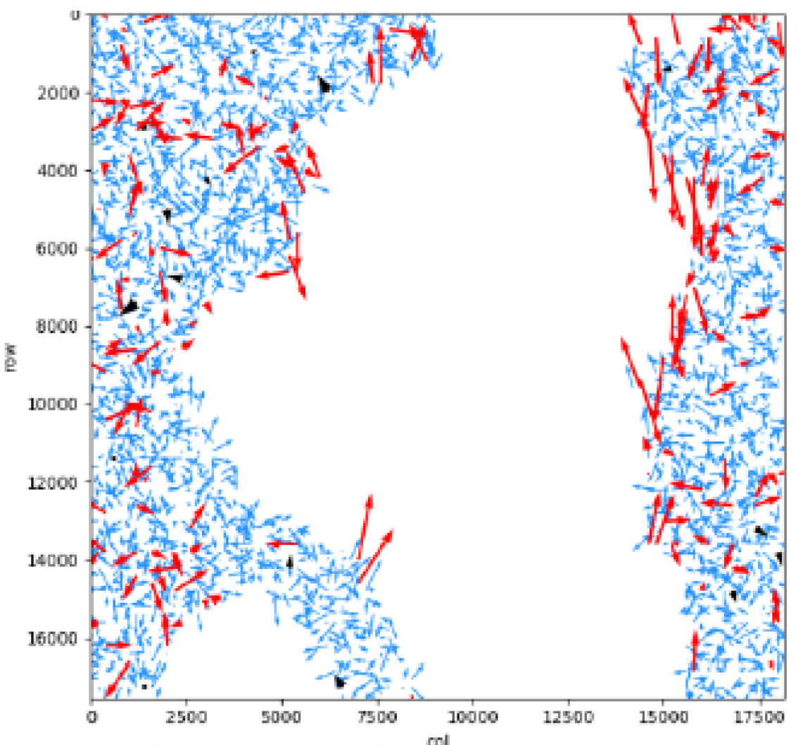
Residuals of the junction points, after refining the geometric parameters. Red arrows have been marked as anomalies and filtered out, while blue arrows are correct.
The Earth Observation Unit is responsible for developing and editing the software on behalf of the CNES. Beyond modelling, LibGEO allows for the optimisation of physical parameters in order to improve localisation based on exogenous observations, generally obtained by a correlator or ground control points.
![]()
The properties of LibGEO
Les features :
-
-
-
Rigorous line of sight modelling
-
RPC and grid modelling
-
Direct (image>ground) and inverse (ground>image) localisation and collocation (image1>image2), intersection on digital elevation models
-
Grid resampling between geometries (image, ground, epipolar)
-
Optimisation of acquisition parameters (attitude, ephemeris…) using Ground Control Points and image correlation to improve geolocation
-
Outlier filtering
-
Geometry for stereo reconstruction
-
Serialization to disk of visualization models in XML format
-
-
The services available :
-
-
- Distribution, corrective, adaptive and evolutionary maintenance, support
- Expertise & consulting and studies
- Customised development: new sensors, geometric correction chain, dedicated tools, etc.
-
The architecture :
-
-
- Open, scalable, cloud-compatible C++ library
- Extensive Python API, handy with tutorials
- Available on Linux CentOs7, portable
-
Optimisation of the visualisation model
Key partners
French Centre National d’Etudes Spatiales (CNES) and Institut Nation de l’Information Géographique et Forestière (IGN)
Key words
observation, satellite, earth, studies, LibGEO, library, modelling, geometry, sensor, CNES, software, finished product, Pleiades Neo, Sentinel, CO3D, Trishna, 3MI, METImage, Metop, MicroCarb, Euclidium, refinement, expertise, localisation, image
SCIENCE FOR EARTH CARE
The Earth Observation Unit of Magellium is an expert in optical space missions and geophysical and biophysical applications. The EO unit provides high level of expertise and full capacity on the whole processing chain, enabling it to respond to all projects from the greatest space orders such as ESA and CNES.