OBS2CO

OBS2CO

OBS2CO

CNES-Hysope-2 treatment line for colour and water quality analysis

nous contacter observation terre magellium

Mission

Monitoring water quality in lakes and rivers

Instruments

Sentinel-2, Landsat, MODIS, Sentinel-3

U

Skills

Combining satellite data, earth observation and in-situ measurements

Date

From 2019 to today

The OBS2CO project

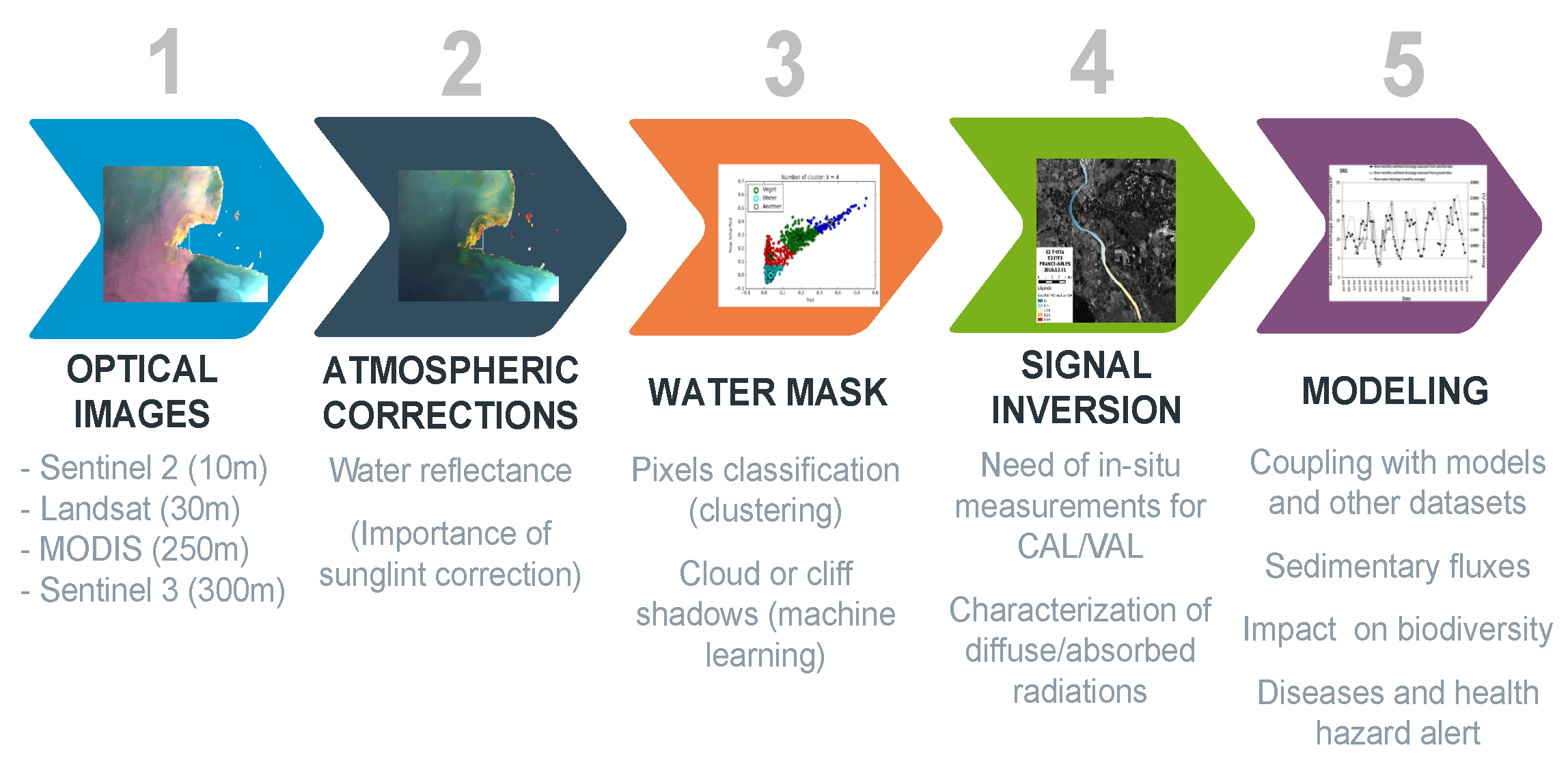
The OBS2CO (OBServation of COntinental water COlour) project enables multi-satellite observation of continental water. The project relies on Earth observation-based water quality monitoring tools and other innovative tools.

In-situ data are essential to calibrate and validate the models. However, satellite data is still essential as it complements the in-situ data.

nous contacter observation terre magellium

obs2co qualite eau hydrologie magellium

Ocean heat content

The Earth Observation unit is in charge of the OBS2CO treatment chain. There is a collaboration between the research teams and the water agencies in order to design a water quality product that complies with the users.

More details can be found in the OBS2CO brochure.

The objectives of OBS2CO


    • Development of an automated processing chain for satellite water quality with atmospheric corrections dedicated to surface waters

    • Large in-island data set for calibration and validation over the full turbidity range (from oligotrophic and transparent to extremely turbid waters)

observation de la terre hydrologie magellium

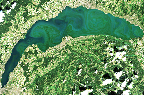
Large phytoplankton bloom on Lake Geneva, Switzerland

Key partners

CNES, GéoscienceSs Environnement Toulouse (GET)

Key words

observation, satellite, earth, studies, quality, water, hydrology, processing chain, in-situ data, atmospheric corrections

observation de la terre

SCIENCE FOR EARTH CARE

The Earth Observation Unit of Magellium  is an expert in optical space missions and geophysical and biophysical applications. The EO unit provides high level of expertise and full capacity on the whole processing chain, enabling it to respond to all projects from the greatest space orders such as ESA and CNES.
Contact

eo@magellium.fr

+33 5 62 24 70 00

1, rue Ariane
31520 Ramonville Saint-Agne FRANCE

More info

www.magellium.com

Follow us

3MI

3MI

3MI

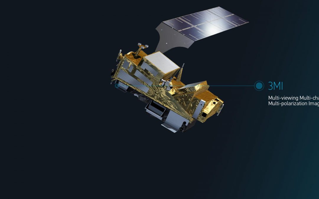
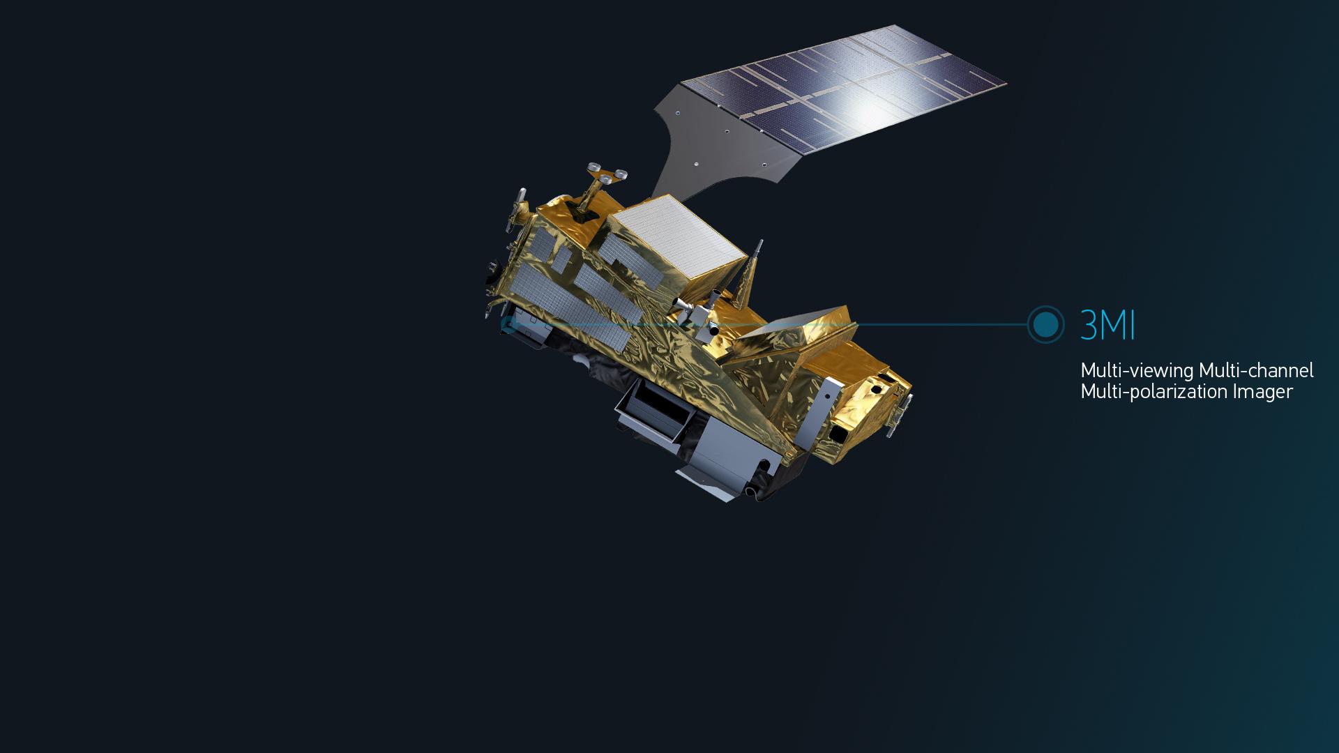
3MI (Multi-acquisition Multi-spectral Band and Multi-polarization) is an imaging instrument of Metop-SG A

nous contacter observation terre magellium

Mission

On Ground Calibration (OGC), définition des algorithmes de traitements des données instrument 3MI (ATBD),

Conception et développement de l’IDS (Instrument Data Simulator) permettant la production des données simulées de niveau 0,

Conception et développement des prototypes GPPs  de traitements des données 3MI permettant la génération des produits de niveau 1 et intermédiaire,

Conception et développement du PAT (Performance Assessment Tool).

Satellites / Instruments

Metop-SG A satellite with 6 instruments including 3MI

U

Skills

Prototyping, simulation, C++ language, L0/L1B1/L1B processing, calibration

Date

From 2016 to today

The Metop-SG A and Metop-SG B satellites

The EPS-SG (EUMETSAT Polar System – Second Generation) programme consists of two satellites: Metop-SG A and Metop-SG B. The objective of this programme is to provide continuity of low earth orbit satellite observations for operational meteorology, oceanography, atmospheric chemistry and climate monitoring. Thus, it will meet the needs of users during the period from 2020 to 2040.

Metop-SG A and Metop-SG B operate in the same orbit and have different configurations. The benefits or applications of this mission are focused on weather forecasting, climate change, air quality (atmospheric composition), hydrology, oceanography, etc.

More general information on the 3MI mission can be found on the EUMETSAT website.

segment sol observation terre 3MI magellium

Illustration of METOP-SG A satellite
© EUMETSAT

The OGC software


The 3MI instrument is under the responsibility of Leonardo, based in Florence (Italy), which is in charge of the design and implementation of the H/W and SW instruments. CSL is the Leonardo subcontractor for the calibration of the 3MI instrument. It will be launched on the A-satellite platform of the global METOP-SG programme, which will be operated by EUMETSAT.

Magellium’s Earth Observation unit is CSL’s subcontractor. It is in charge of the implementation of the 3MI On Ground Calibration (OGC) software and the generation and maintenance of the 3MI ATBD (instrument data processing algorithms).


The 3MI OGC software consists of 3 main components:

 IMOD/CMOD implements the Instrument Model and the Inverted Calibration Model:

IMOD simulates the behaviour of the instrument taking into account Spatial and Spectral filtering, and the different radiometric artefacts such as Dark Current, Non-Linearity, Flat-Field, Straylight, etc…IMOD covers the same functional scope as the L0 processing in IDS

CMOD implements the necessary corrections to compensate for instrument artefacts. CMOD covers the same functional scope as L1B1 processing and RIM processing within GPP.

ICCDB, implemented in NetCDF format, and containing all Key Data Parameters (KDP) used by both 3MI IDS&GPP and 3MI OGC SW.
Linked to ICCDB, the dedicated software allows to simulate a synthetic version of ICCDB for testing purposes.

KDPM implements the calculation of all KDPs from the measurements acquired during the calibration campaigns. It also includes dedicated software to allow the simulation of measurements.

observation terre magellium

3MI IDS and GPP L1B1 project

The context

Magellium’s Earth Observation unit is the subcontractor to Leonardo for 3MI IDS (instrument data simulation) & GPP SW (prototype processing chain to generate products up to L1B1 level).

The 3MI IDS is to be used to replace the current 3MI instrument flight models until its delivery and integration. In the meantime, this should allow the validation of the L1B1 GPP with simulated data.

The 3MI GPP L1B1 is intended to provide a prototype L1B1 processing chain. This processing chain should then be used by EUMETSAT as a reference chain for the operational production chain (PDAP) within the METOP-SG ground segment.

Finally, the 3MI IDS & GPP L1B1 project is currently in its final phase (SRR delivery in 2016, PDR, TRR and V1 in 2017, V2 delivery in 2018, intermediate versions in 2019/2020/2021), taking into account the results of the EM calibration campaign.

The mission

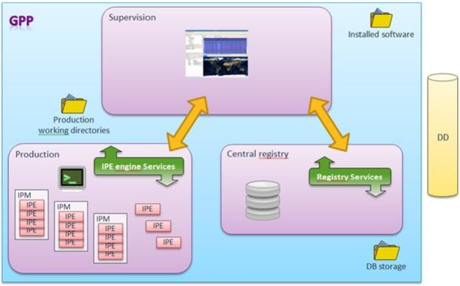
The 3MI GPP L1B1 software consists of three main components:

IDS, the 3MI instrument simulator, generating :

L0 data (Image, Ancillary, NAVATT) in NetCDF4 format and CCSDS format for GPP purposes, simulating future EGSE outputs (3MI and satellite level),

intermediate data L0 and simulated luminance for validation purposes taken into account by the PAT (Performance Analysis Tool),

GPP, the 3MI L1B1 correction processing, taking as input :

CCSDS stream file from IDS or EGSE,

Product L0 (CCSDS packets encapsulated in NetCDF4 format) from IOV, and generating:

Product L0,

→ L1B1 product (to be provided as the main input to the 3MI GPP L1B1/L1B),

→ L1B1 ground radiation and intermediate data for validation purposes taken into account by PAT,

PAT, used to jointly validate IDS and GPP outputs.

GPP 3MI L1B1/L1B processing

Magellium’s Earth Observation unit is a subcontractor of CNES for the prototyping of the processing chain from level L1b1 to level L1B.

3mi magellium gpp metop

The L1b1/L1b processing calculates the Stokes vectors from L1b1 products in the acquisition sensor reference frame. In a first step, the 3 acquisitions, corresponding to the 3 polarisations under which the same spectral band and the same scene were acquired, are co-registered. Then, in a second step, their radiometric model is inverted in order to calculate the Stokes vector. For unpolarised bands, the processing is based on the Stokes parameters of the neighbouring polarised spectral bands.

nous contacter observation terre magellium

Consortium

EUMETSAT, ESA, Leonardo, CSL, CNES

Key words

observation, satellite, earth, ground segment, 3MI, Metop, EUMETSAT, calibration, c++, prototype, L1B1 processing, ground segment

observation de la terre

SCIENCE FOR EARTH CARE

The Earth Observation Unit of Magellium  is an expert in optical space missions and geophysical and biophysical applications. The EO unit provides high level of expertise and full capacity on the whole processing chain, enabling it to respond to all projects from the greatest space orders such as ESA and CNES.
Contact

eo@magellium.fr

+33 5 62 24 70 00

1, rue Ariane
31520 Ramonville Saint-Agne FRANCE

More info

www.magellium.com

Follow us

4DAtlantic

4DAtlantic

4DATLANTIC

Monitoring the global Ocean Heat Content (OHC) of the Atlantic Ocean from space-based observations

agence spatiale europenne esa

Mission

Monitoring the global ocean heat content (OHC) of the Atlantic Ocean

Instruments

GRACE, altimetry missions

U

Skills

Geodetic data processing (altimetry and gravimetry)

Date

From 2019 to today

Le projet 4DATLANTIC

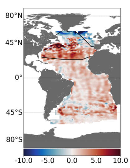
On a global scale, the estimation of the Ocean Heat Content (OHC) is a very good indicator for monitoring the IEE (Earth Energy Imbalance). ESA’s MOHeaCAN project successfully explored the feasibility of monitoring the global ocean heat content from a product based on space-based geodetic observations (altimetry and gravity). This was the first time that a global estimate of OHC and related changes in the IEE from space-based observations was made.

The objective of the 4DAtlantic-OHC project is focused on the Atlantic Ocean and aims to extend the work carried out in the MOHeaCAN project to regional scales where new challenges related to geodetic data processing need to be addressed (coastal zone, taking into account salinity variations…). 

4datlantic ocean heat content earth energy imbalance

Heat content of the Atlantic Ocean

The 4DAtlantic-OHC project is funded by the European Space Agency (ESA).

Find more information on the 4DAtlantic project website.

The objectives

    Estimating the ocean heat content (OHC) over the Atlantic Ocean using space geodetic data

    Conduct a scientific study to better understand the role of the Atlantic Ocean in the climate system

    Promote and transfer the results of the project to implement solutions for society

      Key partners

      ESA, National Oceanographic Centre, LOPS, Mercator Ocean, Met Office, LEGOS, CNES, CNRS, Barcelona Supercomputing Center

      Key words

      observation, satellite, earth, studies, OHC, ocean heat content, EEI, earth energy imbalance, Atlantic Ocean, climate, altimetry, gravity, in-situ data

      observation de la terre

      SCIENCE FOR EARTH CARE

      The Earth Observation Unit of Magellium  is an expert in optical space missions and geophysical and biophysical applications. The EO unit provides high level of expertise and full capacity on the whole processing chain, enabling it to respond to all projects from the greatest space orders such as ESA and CNES.
      Contact

      eo@magellium.fr

      +33 5 62 24 70 00

      1, rue Ariane
      31520 Ramonville Saint-Agne FRANCE

      More info

      www.magellium.com

      Follow us

      GRACEFUL

      GRACEFUL

      GRACEFUL

      GRavimetry, mAgnetism and CorE FLow

      Collaboration between Royal Observatory of Belgium (Véronique Dehant), CNES (Mioara Mandea) and LEGOS (Anny Cazenave)

      graceful legos cnes belgium magellium climat

      Mission

      Detecting dynamic processes from the Earth’s core using a synergy of satellite observations

      Satellites / Instruments

      Satellite observations of the magnetic field (CHAMP, SWARM), gravity (GRACE, GRACE FO) and the Earth’s rotation (IERS)

      U

      Skills

      Processing and analysis of satellite measurements

      Modelling of geophysical processes from the earth’s surface to its deep interior

      Multidisciplinarity – synergy

      Basic research

      Date

      From 2020 to today

      The GRACEFUL project


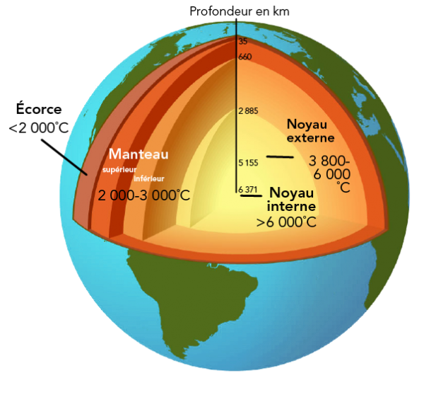
      The GRACEFUL project aims to better understand the internal dynamics of our planet, in particular the Earth’s core. The Earth is made up of a solid metallic core (the inner core), a fluid metallic envelope (the outer core) within which the Earth’s magnetic field is generated by a dynamo effect, a solid envelope made up mainly of silicates (the mantle) and the Earth’s crust (the lithosphere) on which we stand. The atmosphere, ocean, hydrosphere and cryosphere are the Earth’s fluid outer shells.

      As the Earth’s core is located several thousand kilometres below our feet, it is not directly accessible to us. Knowledge of its existence is based on indirect evidence, mainly from seismology, which uses the principle of wave propagation inside a body to produce an “ultrasound” of the Earth’s interior. However, seismology only allows us to obtain a fixed image of the Earth’s interior and does not allow us to study its internal dynamics. This ambitious project aims to use satellite observations of the Earth’s magnetic field, gravity and rotation to better understand the movement of metallic fluid within the outer core and its interactions with the inner core and mantle.

      GRACEFUL observation terre magellium

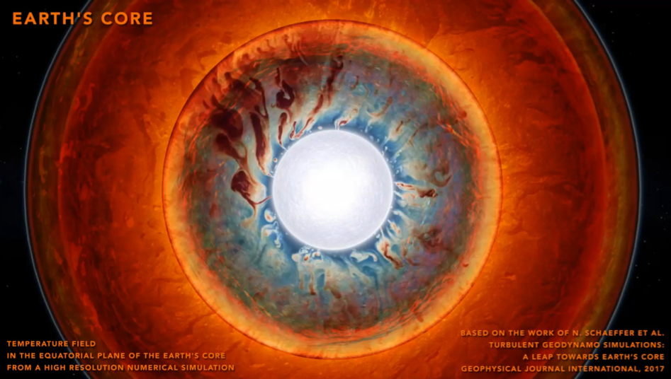
      Temperature field in the equatorial plane of the Earth’s core from a high resolution numerical simulation
      After Schaeffer et al., 2017, GJI

      The GRACEFUL (GRavimetry, mAgnetism, rotation and CorE Flow) project is a Synergy project (number 855677) of the European Research Council (ERC) in the framework of the European Union’s Horizon 2020 research and innovation programme. It is led by Véronique Dehant (Royal Observatory of Belgium), Mioara Mandea (CNES) and Anny Cazenave (LEGOS).

      Visit the official GRACEFUL project website here.

      nous contacter observation terre magellium

      The role of the unit in GRACEFUL


      Magellium’s Earth Observation Unit is responsible for the processing and analysis of space gravity data acquired by the GRACE (Gravity Recovery And Climate Experiment) and GRACE Follow-On missions. The GRACE and GRACE-FO data are then corrected for all surface processes (ice melt, oceanic and atmospheric circulation, water cycle, earthquakes, glacial isostatic adjustment) in order to isolate variations in the gravity field from the deep Earth. These data are then compared with models of the Earth’s interior developed by our partners at the Royal Observatory of Belgium and the IsTerre Institute in Grenoble.

        GRACEFUL observation terre magellium

        Key partners

        CNES, LEGOS, Royal Observatory of Belgium

        Key words

        observation, satellite, Earth, studies, altimetry, gravimetry, Earth field, gravity, rotation, magnetism, Earth core, CNES, Belgium, LEGOS

        observation de la terre

        SCIENCE FOR EARTH CARE

        The Earth Observation Unit of Magellium  is an expert in optical space missions and geophysical and biophysical applications. The EO unit provides high level of expertise and full capacity on the whole processing chain, enabling it to respond to all projects from the greatest space orders such as ESA and CNES.

        Contact

        eo@magellium.fr

        +33 5 62 24 70 00

        1, rue Ariane
        31520 Ramonville Saint-Agne FRANCE

        More info

        www.magellium.com

        Follow us

        Trishna

        Trishna

        Trishna

        Thermal infraRed Imaging Satellite for High-resolution Natural resource Assessment
        Technical support for CNES

        cnes centre national etudes spatiales observation terre

        Mission

        Measure surface temperatures all over the globe

        Satellite / Instruments

        Trishna satellite

        TIR (Thermal InfraRed)
        VNIR/SWIR (Visible and Near InfraRed/Short Wave InfraRed)

        U

        Skills

        Geometric modelling

        Date

        Expected launch : 2025

        The Trishna project


        Vegetation plays an important role in the functioning of the Earth’s surface as it regulates the exchange of energy and substances (CO2, H2O, etc.). Visible sensors have made it possible to monitor the evolution (growth, maturity, ageing) of vegetation from space. However, plants can suffer from water stress, which raises the temperature of the plants. This stress can be observed in the infrared thermal range.

        Currently, such space-based thermal measurements only exist at a resolution of about 100 metres at a monthly frequency, while at the global daily scale they are only available at kilometre resolution.

        The Trishna mission, a collaboration between CNES (France) and ISRO (India), will collect thermal infrared images of the Earth’s surface with a resolution of 57 metres and a revisit every three days.

        observation terre magellium

        trishna cnes magellium vegetation

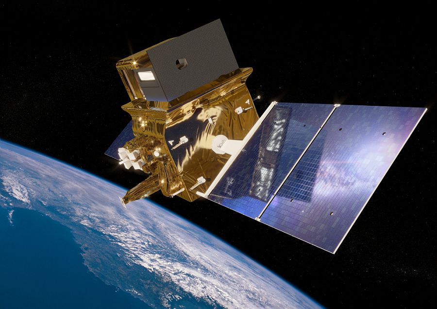
        Illustration of Trishna satellite
        © CNES/ill./REGY Michel, 2021

        The Trishna satellite is therefore a specialised infrared and earth observation satellite. It observes vegetation zones and monitors soil temperatures. In this way, it can monitor the evolution of crops and vegetation around the world.

        The unit is involved in the geometric modelling of the acquisitions sent by the satellite.

        To find out more about the Trishna mission, visit the CNES website for Trishna.

        nous contacter observation terre magellium

        The objectives of Trishna


          Part of the unit is based in the CNES offices in order to best meet the needs of the project.

          The objective of the Trishna project is to understand the local evolution of biological (water stress, transpiration), physical (evaporation, sublimation, plume zones) and climatic (global observation over time) phenomena related to the water cycle.

          Key words

          observation, satellite, earth, studies, geometric modelling, Trishna, CNES, France, ISRO, India, thermal sensor

          observation de la terre

          SCIENCE FOR EARTH CARE

          The Earth Observation Unit of Magellium  is an expert in optical space missions and geophysical and biophysical applications. The EO unit provides high level of expertise and full capacity on the whole processing chain, enabling it to respond to all projects from the greatest space orders such as ESA and CNES.

          Contact

          eo@magellium.fr

          +33 5 62 24 70 00

          1, rue Ariane
          31520 Ramonville Saint-Agne FRANCE

          More info

          www.magellium.com

          Follow us