Lunar DEM

Lunar DEM

Lunar DEM

3D reconstruction of the lunar surface by stereo-restitution

Mission

Reconstruction 3D de la surface lunaire

Instruments

Sonde Lunar Reconnaissance Orbiter (LRO)

U

Compétences

Reconstruction 3D, géométrie, modélisation numérique de surface

Date

De 2020 à aujourd’hui

The Lunar DEM project


This project is part of a study for Airbus Defense & Space.

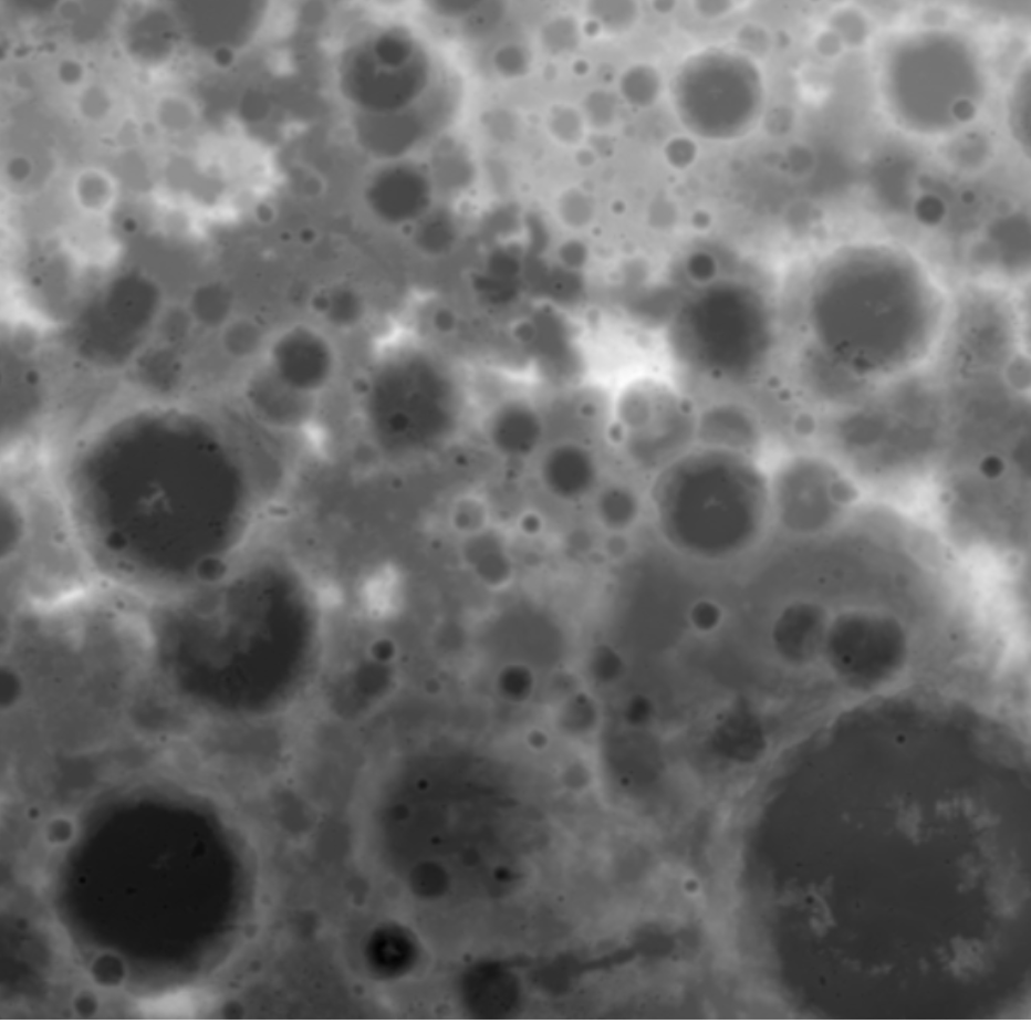
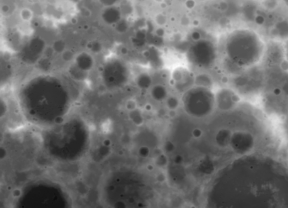
The objective of this project is to calculate the most detailed Digital Surface Model (DSM) possible. This DSM is calculated from the images of the Narrow Angle Scanning (NAC) cameras of the Lunar Reconnaissance Orbiter (LRO).

LRO is a NASA robotic spacecraft. Launched in 2009, it is part of the US Vision for Space Exploration programme. The data received by this spacecraft is characterised as being essential for “planning NASA’s future human and robotic missions to the Moon”.

More about LRO here.

nous contacter observation terre magellium

The LUNAR DEM objectives


      • Prototyping of a processing chain performing the optimisation of the geometric model of the cameras

      • Stereo-restitution of the lunar surface and optimisation by the shape-from-shading algorithm
lunar dem lune magellium airbus

Key partner

CNES

Key words

observation, satellite, Moon, studies, DSM, MNS, geometry, sensor, reconstruction, 3D, NASA

observation de la terre

SCIENCE FOR EARTH CARE

The Earth Observation Unit of Magellium  is an expert in optical space missions and geophysical and biophysical applications. The EO unit provides high level of expertise and full capacity on the whole processing chain, enabling it to respond to all projects from the greatest space orders such as ESA and CNES.


Contact

eo@magellium.fr

+33 5 62 24 70 00

1, rue Ariane
31520 Ramonville Saint-Agne FRANCE

More info

www.magellium.com

Follow us

Smoke detection

Smoke detection

Smoke detection

Mission

Smoke detection after a fire and analysis of the impact on agriculture

U

Skills

Algorithm development, studies

Date

From 2020 to 2021

The work on smoke detection


The smoke emitted by fires, even thousands of kilometres from the source, can have a significant impact on the surrounding vegetation. This is particularly the case for vineyards, as the vinasse produced by smoke-affected grapes will have a strongly modified taste.

Fortunately, the Copernicus Atmospheric Monitoring Service (CAMS) provides a large amount of atmospheric data extracted from various physical models, satellite data and in situ observations.

The specific CAMS data indicate the location of smoke at any given time from a selected fire, both at ground level and at several heights above the ground. A first study by the Centre National d’Etudes Spatiales (CNES) showed that the specific CAMS data are difficult to use to determine the affected vineyards.

fumée detection copernicus magellium

The unit’s work consists of extending this proof-of-concept study by developing automatic tools to easily retrieve data stored in CAMSAPI, visualise it, extract localised data and test this methodology on a large number of people.

nous contacter observation terre magellium

The objectives of the smoke detection


      • Automatic recovery of CAMS data
      • Smoke impact index
      • Data visualization
      • QGIS plugin
      • Comparison with S5P and IASI acquisitions

Key partners

CNES, SPASCIA

Key words

observation, satellite, earth, studies, smoke, detection, copernicus, vineyard, agriculture, impact

observation de la terre

SCIENCE FOR EARTH CARE

The Earth Observation Unit of Magellium  is an expert in optical space missions and geophysical and biophysical applications. The EO unit provides high level of expertise and full capacity on the whole processing chain, enabling it to respond to all projects from the greatest space orders such as ESA and CNES.
Contact

eo@magellium.fr

+33 5 62 24 70 00

1, rue Ariane
31520 Ramonville Saint-Agne FRANCE

More info

www.magellium.com

Follow us

MoHeaCAN

MoHeaCAN

Moheacan

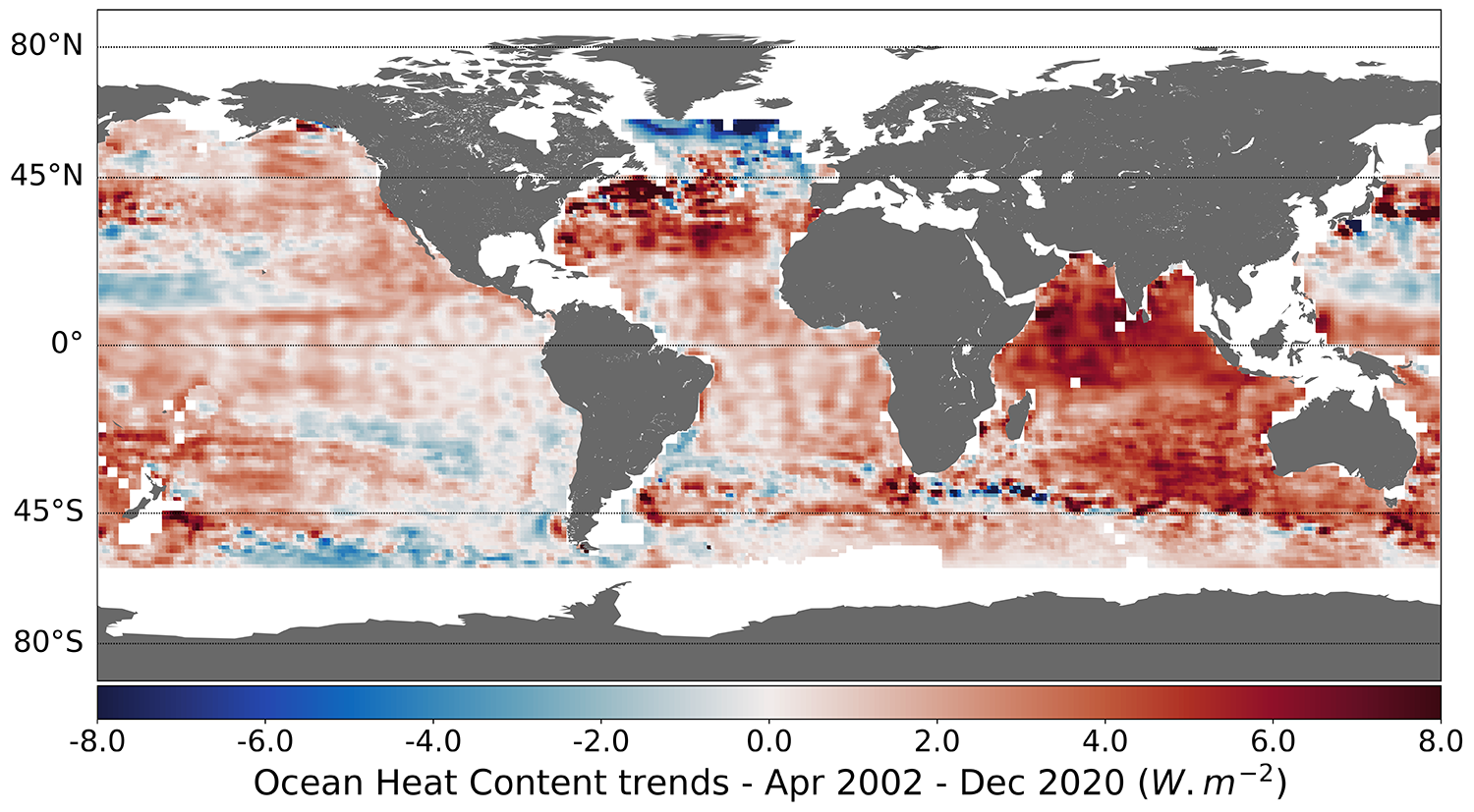
Monitoring ocean heat content (OHC) and Earth energy imbalance (EEI) from space observations

agence spatiale europenne esa

Mission

Global Ocean Heat Content (OHC) and Earth Energy Imbalance (EEI) monitoring

Instruments

GRACE

U

Skills

Altimetry and gravity data

Date

From 2019 to today

The MOHeaCAN project

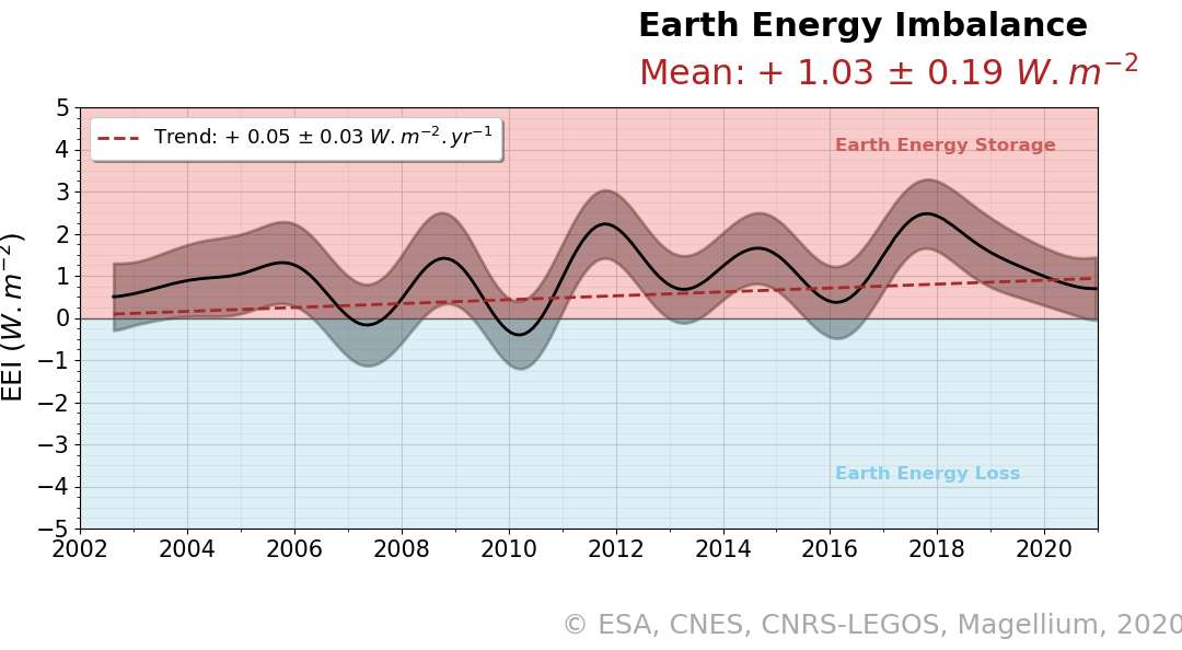
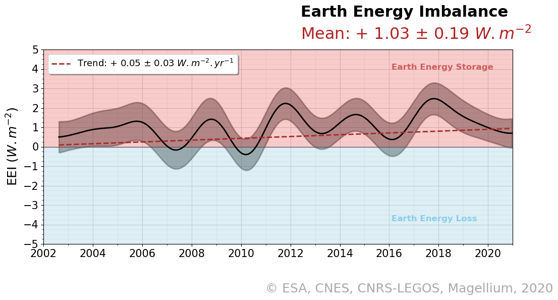
Since the industrial era, emissions of greenhouse gases (GHGs) into the atmosphere due to human activities have reduced the amount of infrared energy that the Earth emits into space. Today, the Earth emits less energy into space than it receives from the sun. As a result, there is an Earth Energy Imbalance (EEI).

Because of this IEE, the climate system stores energy, mainly in the form of heat. This excess energy disrupts many things, including the global hydro-energy cycle, and creates what is known as climate change. Excess energy heats the oceans, causing sea levels to rise and sea ice to melt. It melts the land ice, also causing sea level rise. It causes a rise in surface temperatures, altering the hydrological cycle and producing droughts and floods.

Therefore, estimating and analysing the IEE is essential to understanding the Earth’s changing climate.

nous contacter observation terre magellium

ocean heat content magellium climate change

Heat content of the oceans

The MOHeaCAN (Monitoring Ocean Heat Content and earth energy imbalANce) project is an ESA-supported project led by the Magellium Earth Observation Unit with scientific experts from LEGOS.

Thanks to the support of CNES, estimates of GOHC (Global Ocean Heat Content) and IEE are further improved and available on the ODATIS/AVISO portal.

In parallel, the CNRS is funding the evaluation of the IEE against other estimates, based on space and/or in situ observations.

Find more information on the MOHeaCAN website project.

The objectives of MOHeaCAN

        • Calculate global ocean heat content (GOHC) and Earth energy imbalance (EEI) from space geodetic data

        • Provide the possibility to extend heat content monitoring for future applications and solutions
    climat environnement hydrologie observation terre magellium

    Key words

    ESA, Centre National Océanographique, LOPS, Mercator Ocean, Met Office, LEGOS, CNES, CNRS, Barcelona Supercomputing Center

    Key words

    observation, satellite, earth, studies, OHC, ocean heat content, EEI, earth energy imbalance, climate, altimetry, gravity, in-situ data, geodetic data

    observation de la terre

    SCIENCE FOR EARTH CARE

    The Earth Observation Unit of Magellium  is an expert in optical space missions and geophysical and biophysical applications. The EO unit provides high level of expertise and full capacity on the whole processing chain, enabling it to respond to all projects from the greatest space orders such as ESA and CNES.

    Contact

    eo@magellium.fr

    +33 5 62 24 70 00

    1, rue Ariane
    31520 Ramonville Saint-Agne FRANCE

    More info

    www.magellium.com

    Follow us

    VENµS

    VENµS

    VENµS

    Vegetation and Environment Monitoring on a New Micro-Satellite
    Technical support to CNES

    cnes centre national etudes spatiales observation terre
    venus venµs satellite cnes magellium observation terre vegetation

    Mission

    Close and regular monitoring of vegetation on the Earth’s surface in important selected areas

    Instruments

    Camera with 12 narrow spectral bands (420 to 910nm), native resolution of 5m

    U

    Skills

    Radiometry, calibration, algorithmic corrections

    Date

    From 2003 to today
    Launch date : 2017

    The VENµS project


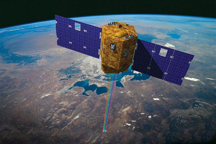
    The VENµS satellite

    The VENµS project is the result of cooperation between the French and Israeli agencies (CNES and ISA). It combines a scientific objective of monitoring vegetation with a technical objective of testing a new type of thruster (Hall effect).

    VENµS is a research satellite containing two devices: an electric Hall effect thruster (managed by ISA) and a multispectral optical camera. VENµS provides images of 110 selected sites around the world: forests, crops, protected natural areas, etc. Since 2 August 2017, the satellite has been acquiring images in 12 spectral bands, using a camera provided by CNES. These images have a high spatial resolution (between 5 and 10 m on the ground with a field of view of 27 km) and a high temporal resolution (initially 2 days, reduced to 1 day following the lowering of the orbit). These characteristics set it apart from other satellites in operation and offer a revisit frequency and spatial finesse that are particularly well suited to the study of vegetation.

    VENµS is particularly well suited to the study of vegetation. It allows us to understand and model the influence of environmental factors, human activities and climate change on continental surfaces.


    observation terre magellium satellite geometrie

    Illustration of the VENµS satellite
    © CNES/IDE./SARIAN Robin, 2015

    The unit’s work

    Magellium’s Earth Observation unit supported CNES on the mission preparatory studies and during the flight acceptance phase, working in particular on the radiometric correction algorithms of the processing chains and the performance study.

    In November 2020, VENμS completed the first phase of its mission. This phase, called VM01, provided about 150 accurate time series at selected scientific sites over nearly three years. Extensive work was carried out to calibrate the camera and assess the quality of the products. Not everything worked as planned before the launch and a great deal of work was needed to correct certain defects in the camera or to improve the geometric registration of the images. It was especially during this VM1 phase that Magellium’s Earth Observation unit redoubled its efforts to ensure that the quality of the images was as high as possible.
    Recently, an article on the characteristics of the VENµS mission appeared in the journal Remote Sensing and can be visited here.

    For more information on the VENµS mission, visit the CNES website.

    nous contacter observation terre magellium

    The objectives of VENµS

      Part of the unit is based in the CNES buildings to better meet the needs of the project.

      Our activity was mainly focused on:

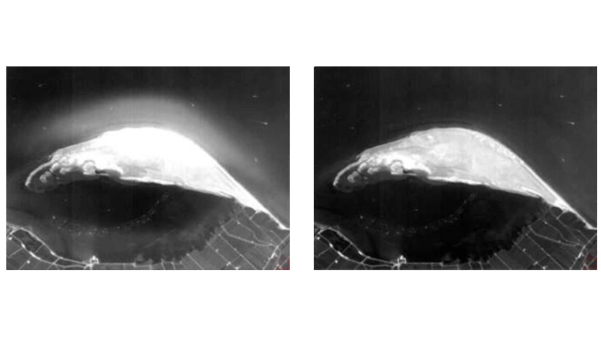
          • Study and validation of a stray light correction algorithm
          • Calibration of radiometric models (dark current, non-linearity)
          • Estimation of cloud altitude by stereoscopy
          • Estimation of the MTF (Modulation Transfer Function)
      VENµS magellium observation terre CNES

      Stray light before and after correction

      Key words

      observation, earth, satellite, CNES, space agency, vegetation, study, science, biosphere, processing chain, climate, climate change

      observation de la terre

      SCIENCE FOR EARTH CARE

      The Earth Observation Unit of Magellium  is an expert in optical space missions and geophysical and biophysical applications. The EO unit provides high level of expertise and full capacity on the whole processing chain, enabling it to respond to all projects from the greatest space orders such as ESA and CNES.
      Contact

      eo@magellium.fr

      +33 5 62 24 70 00

      1, rue Ariane
      31520 Ramonville Saint-Agne FRANCE

      More info

      www.magellium.com

      Follow us

      QRNN

      QRNN

      QRNN

      Implementation of a Quantile Regression Neural Network

      Mission

      Uncertainty estimation via neural networks: recovery of atmospheric 𝐶𝑂2 and associated uncertainties

      Instruments

      IASI, AMSU

      U

      Skills

      Radiometry, algorithmic development

      Date

      From 2019 to 2021

      The QRNN project

      The extraction and analysis of geophysical parameters from remote sensing measurements plays a crucial role in the knowledge of the Earth’s physical phenomena. Indeed, greenhouse gases are responsible for important effects on our atmosphere, such as the Earth’s climate change.

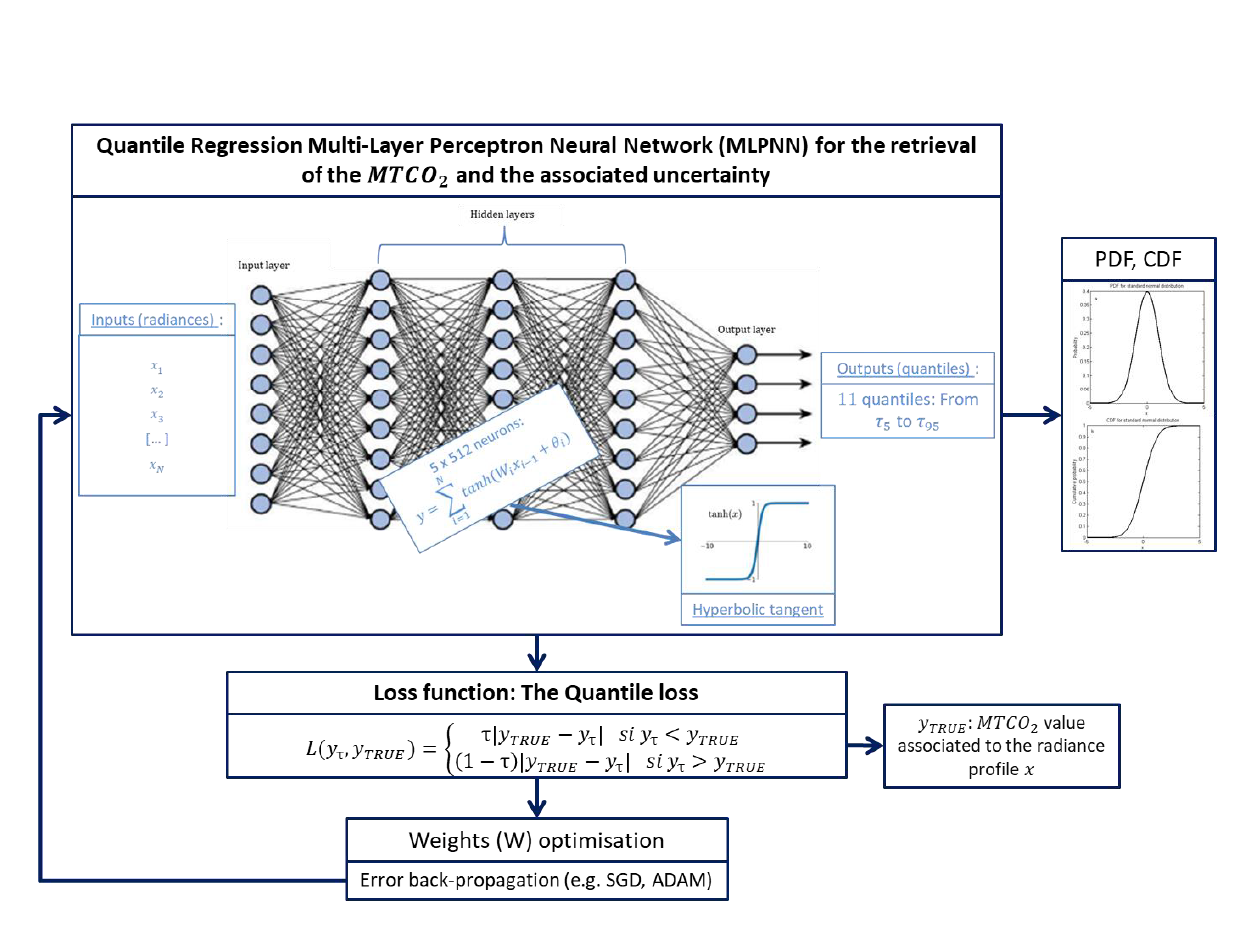
      In this context, methods based on machine learning algorithms have become important in the scientific community. Multi-layer perceptual neural networks (MLPs) have proven to provide good estimates of atmospheric parameters. Also, they have proven to be more efficient (in terms of computational cost and processing of non-linear systems/models) than classical inversion methods, such as the optimal estimation method (OEM).

      However, classical NR techniques do not provide information on the uncertainty of the recovered parameters.
      Yet this uncertainty information is essential for the exploitation of scientific products. For example, it is important for their use in systems for analysing and predicting atmospheric composition and/or dynamics.

      regression quantile co2 magellium

      Within this framework, the unit is in charge of understanding and estimating the potential of obtaining data on the composition of the thermal atmosphere, more precisely, on the content of 𝑪𝑶𝟐 in the troposphere. These measurements are made from infrared hyperspectral survey instruments such as IASI, IASI-NG or OCO-2. Therefore, the unit must be able to determine the uncertainty associated with them, using methods based on neural networks, in order to prepare future missions (e.g. Microcarb).

      This work was conducted as part of a CNES project.

      nous contacter observation terre magellium

      The objectives of QRNN


          • Implementation of a quantile regression MLP (QRNN) for the estimation of atmospheric 𝑪𝑂2 content
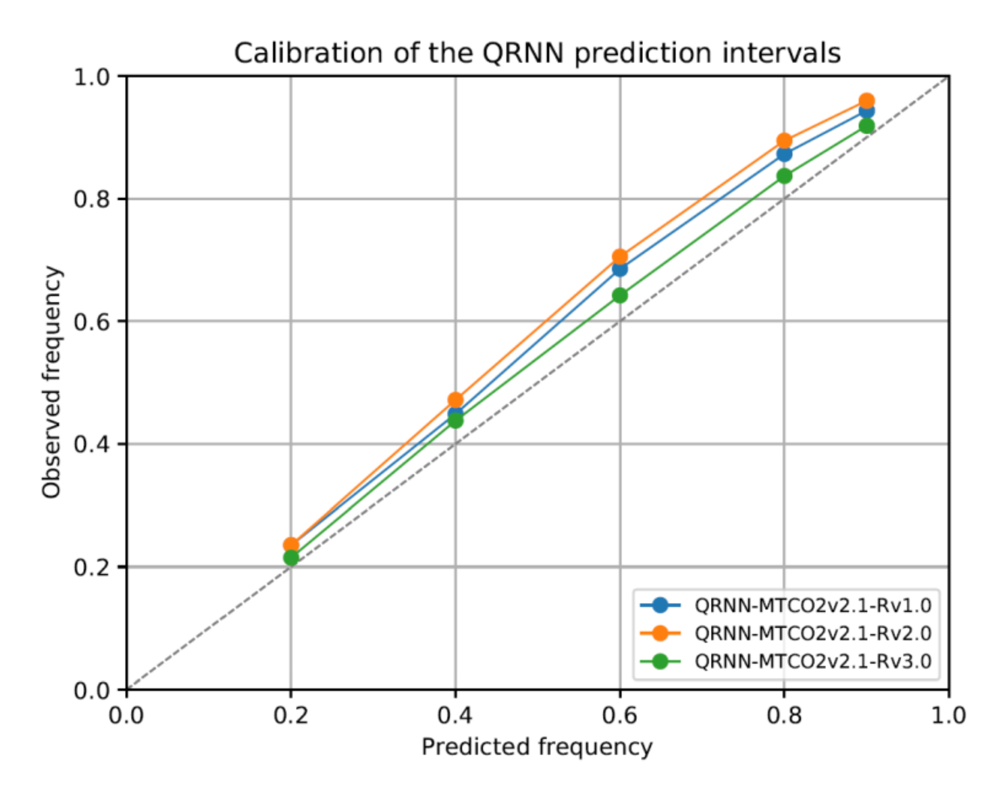
          • Validation of the uncertainty associated with the inverted 𝑪𝑂2 values provided by the QRNN
          • Comparison of the inversions and associated uncertainties provided by the QRNN with those of more classical methods (OEM, Monte-Carlo Markov Chain – MCMC)
        regression quantile co2 magellium

        Key partners

        CNES, SPASCIA, L’Observatoire de Paris, Laboratoire d’Etude du Rayonnement et de la Matière en Astrophysique (LERMA)

        Key words

        observation, satellite, earth, studies, uncertainty, atmospheric data, CO2, regression, quantile, neural networks, GHG, greenhouse gases, climate change, climate

        observation de la terre

        SCIENCE FOR EARTH CARE

        The Earth Observation Unit of Magellium  is an expert in optical space missions and geophysical and biophysical applications. The EO unit provides high level of expertise and full capacity on the whole processing chain, enabling it to respond to all projects from the greatest space orders such as ESA and CNES.
        Contact

        eo@magellium.fr

        +33 5 62 24 70 00

        1, rue Ariane
        31520 Ramonville Saint-Agne FRANCE

        More info

        www.magellium.com

        Follow us